Grondvlakte van Nieuw Orleans, de Hoofdstad van Louisiana: Tirion c. 1760
-
Title: Grondvlakte van Nieuw Orleans, de Hoofdstad van Louisiana
- Author: Isaac Tirion
- Date: c. 1760
- Medium: Hand-colored copperplate engraving
- Condition: Very Good Plus - issued center fold, some areas of slight foxing
- Inches: 17 5/8 x 13 [Image]
- Centimeters: 45.19 x 33.33 [Image]
- Product ID: 102074
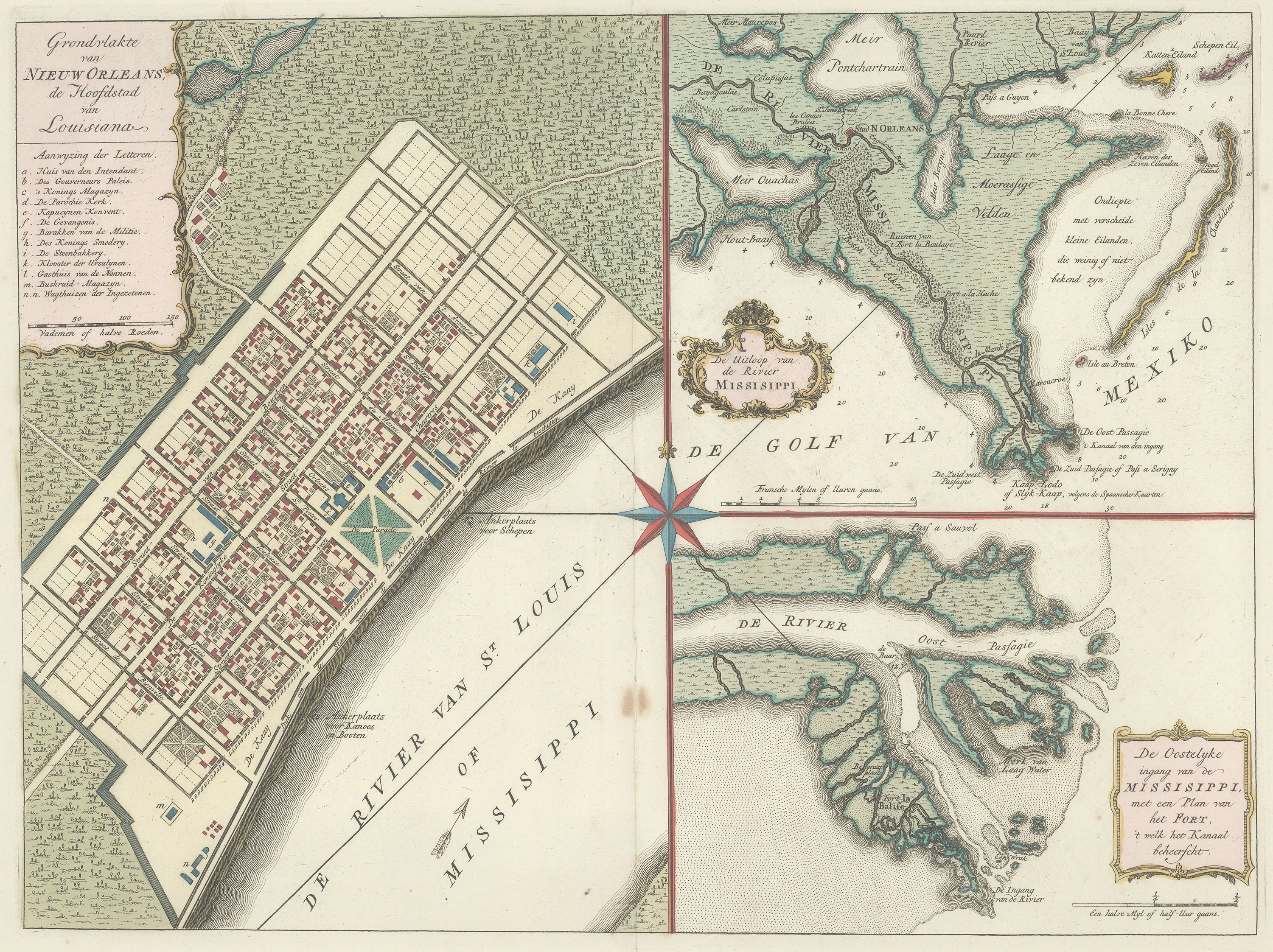
Grondvlakte van Nieuw Orleans, de Hoofdstad van Louisiana
"Grounds of New Orleans, the Capital of Louisiana."
Map of the city of New Orleans, Louisiana and environs by Dutch cartographer Isaac Tirion. Tirion based his map on one dating to 1720 produced by French royal cartographer Louis Brion de la Tour. The left half of the page contains a plan of the city proper, what is today the French Quarter. Within its title cartouche, a legend indicates the locations of major buildings and sites around the city:
Aanwyzing der Letteren. ["Designation of the Letters."]
a. Huis van den Intendant. ["House of the Intendant."]
b. Des Gouverneurs Paleis. ["The Governor's Palace."]
c. 's Konings Magazyn ["The King's Magazine."]
d. De Parochie Kerk. ["The Parish Church."]
e. Kapucynen Konvent. ["Capuchin Convent."]
f. De Gevengenis. ["The Prison."]
g. Barakken van de Militie ["Barracks of the Militia"]
h. Des Konings Smedery. ["The King's Forge."]
i. De Steenbakkery. ["The Brick Bakery."]
k. Klouster der Ursulynen. ["Cloister of the Ursulines."]
l. Gasthuis van de Nonnen. ["Guesthouse of the Nuns."]
m. Buskruid-Magazyn. ["Gunpowder Magazine."]
n. n. Wagthuizen der Ingezetenen. ["Carriage house of the Residents."]
To the upper right, Tirion includes a map of De Uitloop van de Rivier Missisippi ["The Outlet of the Mississippi River"]. This features Lakes Pontchartrain, Borgne, and Ouachas, and labels the area's various small islands. Tirion notes locations for ships to enter the Mississippi from the Gulf, and comments on the surrounding terrain: Ondiepte met verscheide kleine Eilanden, die weinig of niet bekend zyn ["Shoal with several small Islands, little or unknown"].
The bottom right portion of the map, titled De Oostelyke ingang van de Mississippi, met een Plan van het Fort, 't welk het Kanaal beheerscht ["The East Entrance of the Mississippi, with a Plan of the Fort Dominating the Channel"] depicts a detail of the map above.
-
Title: Grondvlakte van Nieuw Orleans, de Hoofdstad van Louisiana
- Author: Isaac Tirion
- Date: c. 1760
- Medium: Hand-colored copperplate engraving
- Condition: Very Good Plus - issued center fold, some areas of slight foxing
- Inches: 17 5/8 x 13 [Image]
- Centimeters: 45.19 x 33.33 [Image]
- Product ID: 102074
Grondvlakte van Nieuw Orleans, de Hoofdstad van Louisiana
"Grounds of New Orleans, the Capital of Louisiana."
Map of the city of New Orleans, Louisiana and environs by Dutch cartographer Isaac Tirion. Tirion based his map on one dating to 1720 produced by French royal cartographer Louis Brion de la Tour. The left half of the page contains a plan of the city proper, what is today the French Quarter. Within its title cartouche, a legend indicates the locations of major buildings and sites around the city:
Aanwyzing der Letteren. ["Designation of the Letters."]
a. Huis van den Intendant. ["House of the Intendant."]
b. Des Gouverneurs Paleis. ["The Governor's Palace."]
c. 's Konings Magazyn ["The King's Magazine."]
d. De Parochie Kerk. ["The Parish Church."]
e. Kapucynen Konvent. ["Capuchin Convent."]
f. De Gevengenis. ["The Prison."]
g. Barakken van de Militie ["Barracks of the Militia"]
h. Des Konings Smedery. ["The King's Forge."]
i. De Steenbakkery. ["The Brick Bakery."]
k. Klouster der Ursulynen. ["Cloister of the Ursulines."]
l. Gasthuis van de Nonnen. ["Guesthouse of the Nuns."]
m. Buskruid-Magazyn. ["Gunpowder Magazine."]
n. n. Wagthuizen der Ingezetenen. ["Carriage house of the Residents."]
To the upper right, Tirion includes a map of De Uitloop van de Rivier Missisippi ["The Outlet of the Mississippi River"]. This features Lakes Pontchartrain, Borgne, and Ouachas, and labels the area's various small islands. Tirion notes locations for ships to enter the Mississippi from the Gulf, and comments on the surrounding terrain: Ondiepte met verscheide kleine Eilanden, die weinig of niet bekend zyn ["Shoal with several small Islands, little or unknown"].
The bottom right portion of the map, titled De Oostelyke ingang van de Mississippi, met een Plan van het Fort, 't welk het Kanaal beheerscht ["The East Entrance of the Mississippi, with a Plan of the Fort Dominating the Channel"] depicts a detail of the map above.
Description
-
Title: Grondvlakte van Nieuw Orleans, de Hoofdstad van Louisiana
- Author: Isaac Tirion
- Date: c. 1760
- Medium: Hand-colored copperplate engraving
- Condition: Very Good Plus - issued center fold, some areas of slight foxing
- Inches: 17 5/8 x 13 [Image]
- Centimeters: 45.19 x 33.33 [Image]
- Product ID: 102074
Grondvlakte van Nieuw Orleans, de Hoofdstad van Louisiana
"Grounds of New Orleans, the Capital of Louisiana."
Map of the city of New Orleans, Louisiana and environs by Dutch cartographer Isaac Tirion. Tirion based his map on one dating to 1720 produced by French royal cartographer Louis Brion de la Tour. The left half of the page contains a plan of the city proper, what is today the French Quarter. Within its title cartouche, a legend indicates the locations of major buildings and sites around the city:
Aanwyzing der Letteren. ["Designation of the Letters."]
a. Huis van den Intendant. ["House of the Intendant."]
b. Des Gouverneurs Paleis. ["The Governor's Palace."]
c. 's Konings Magazyn ["The King's Magazine."]
d. De Parochie Kerk. ["The Parish Church."]
e. Kapucynen Konvent. ["Capuchin Convent."]
f. De Gevengenis. ["The Prison."]
g. Barakken van de Militie ["Barracks of the Militia"]
h. Des Konings Smedery. ["The King's Forge."]
i. De Steenbakkery. ["The Brick Bakery."]
k. Klouster der Ursulynen. ["Cloister of the Ursulines."]
l. Gasthuis van de Nonnen. ["Guesthouse of the Nuns."]
m. Buskruid-Magazyn. ["Gunpowder Magazine."]
n. n. Wagthuizen der Ingezetenen. ["Carriage house of the Residents."]
To the upper right, Tirion includes a map of De Uitloop van de Rivier Missisippi ["The Outlet of the Mississippi River"]. This features Lakes Pontchartrain, Borgne, and Ouachas, and labels the area's various small islands. Tirion notes locations for ships to enter the Mississippi from the Gulf, and comments on the surrounding terrain: Ondiepte met verscheide kleine Eilanden, die weinig of niet bekend zyn ["Shoal with several small Islands, little or unknown"].
The bottom right portion of the map, titled De Oostelyke ingang van de Mississippi, met een Plan van het Fort, 't welk het Kanaal beheerscht ["The East Entrance of the Mississippi, with a Plan of the Fort Dominating the Channel"] depicts a detail of the map above.