Texas, Indian Territory and Oklahoma: American Book Company, 1890
- Title: Texas, Indian Territory and Oklahoma
- Author: American Book Company
- Date: 1890
- Condition: Very good - holes at right margin from original stab binding, light stain in bottom margin at right not into image, some old scotch tape on verso
- Inches: 8 1/4 x 11 [Image]
- Centimeters: 20.95 x 27.94 [Image]
- Product ID: 308316
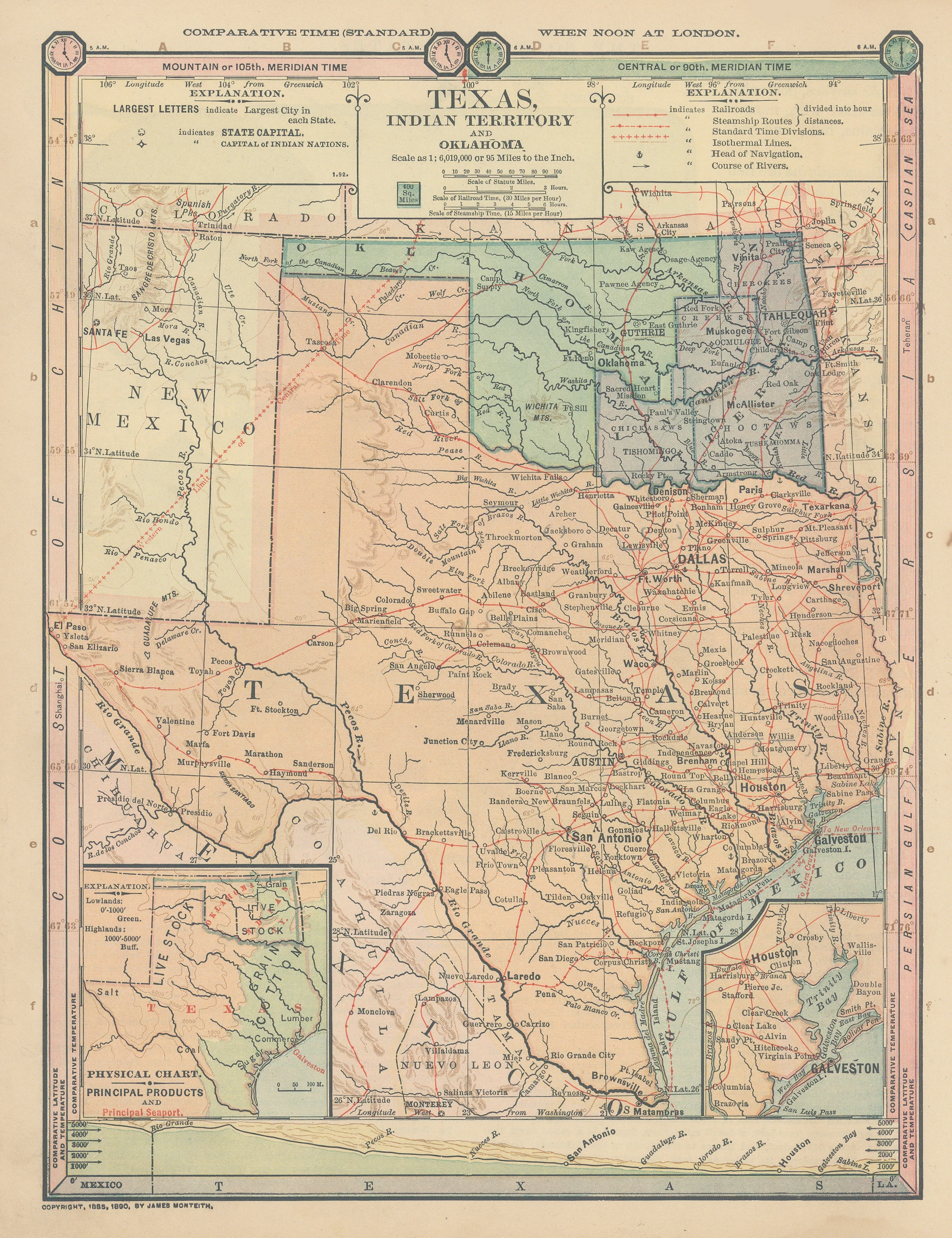
Rare Map of Texas and Indian Territory
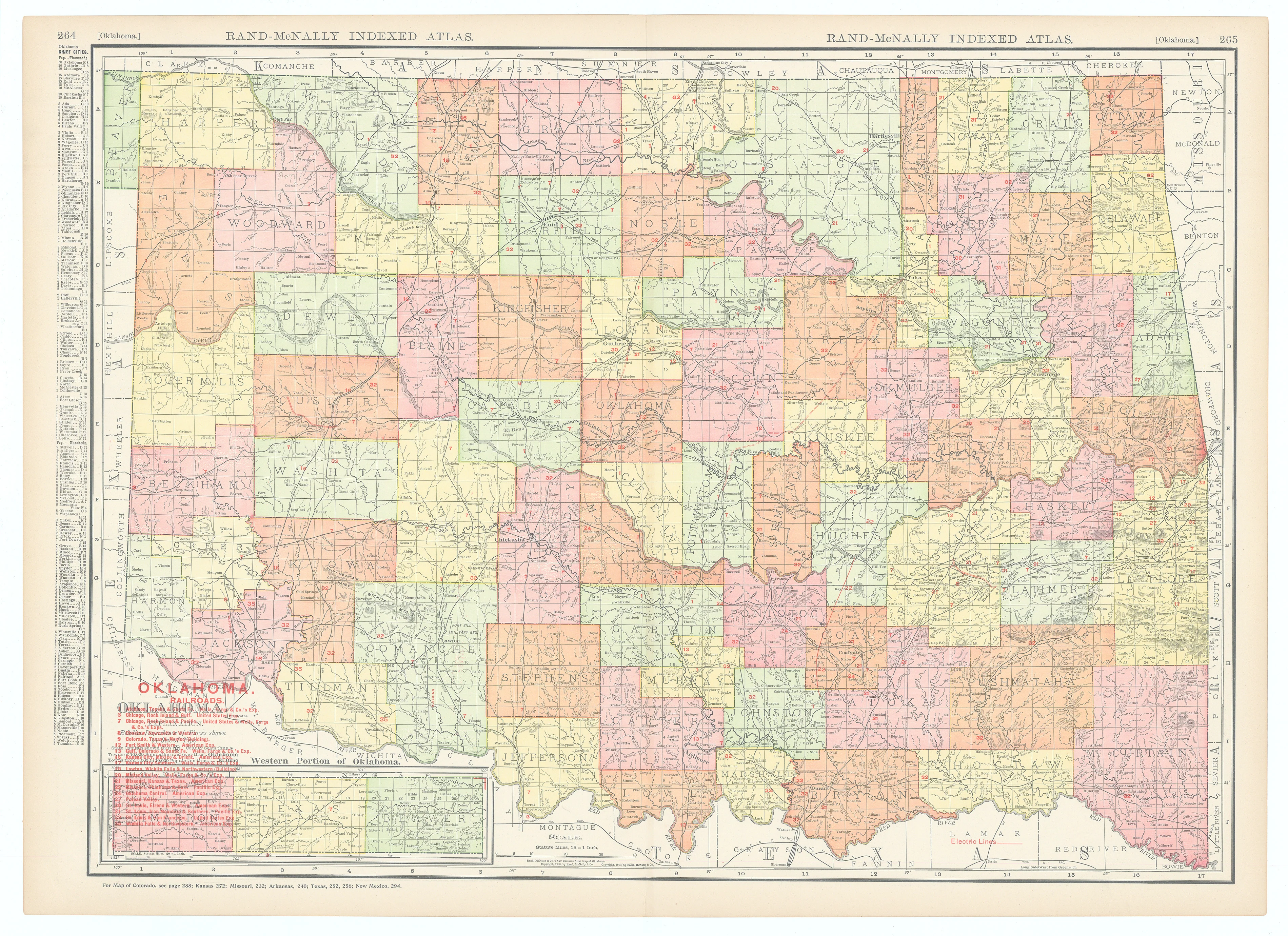
Although this beautiful, original relief line engraving by James Monteith is entitled "Texas, Indian Territory and Oklahoma," its central focus is Texas. The quality of printing and paper is very good. The colors are strong. The copyright "1885, 1890 by James Monteith" appears on the face at bottom left.
The map is very unique because of its unusual utility. Steamship routes and railway lines (with stations) are shown with red lines. The direction or course in which rivers flow is shown by "arrows" and the head of river navigation by "anchors." Isothermal lines are also shown. Comparative latitudes and comparative temperatures are on charts on the right and left margins of the map, along with mean temperature. The top margin reflects comparative time zones.
- Title: Texas, Indian Territory and Oklahoma
- Author: American Book Company
- Date: 1890
- Condition: Very good - holes at right margin from original stab binding, light stain in bottom margin at right not into image, some old scotch tape on verso
- Inches: 8 1/4 x 11 [Image]
- Centimeters: 20.95 x 27.94 [Image]
- Product ID: 308316
Rare Map of Texas and Indian Territory
Although this beautiful, original relief line engraving by James Monteith is entitled "Texas, Indian Territory and Oklahoma," its central focus is Texas. The quality of printing and paper is very good. The colors are strong. The copyright "1885, 1890 by James Monteith" appears on the face at bottom left.
The map is very unique because of its unusual utility. Steamship routes and railway lines (with stations) are shown with red lines. The direction or course in which rivers flow is shown by "arrows" and the head of river navigation by "anchors." Isothermal lines are also shown. Comparative latitudes and comparative temperatures are on charts on the right and left margins of the map, along with mean temperature. The top margin reflects comparative time zones.
Original: $495.00
-65%$495.00
$173.25Description
- Title: Texas, Indian Territory and Oklahoma
- Author: American Book Company
- Date: 1890
- Condition: Very good - holes at right margin from original stab binding, light stain in bottom margin at right not into image, some old scotch tape on verso
- Inches: 8 1/4 x 11 [Image]
- Centimeters: 20.95 x 27.94 [Image]
- Product ID: 308316
Rare Map of Texas and Indian Territory
Although this beautiful, original relief line engraving by James Monteith is entitled "Texas, Indian Territory and Oklahoma," its central focus is Texas. The quality of printing and paper is very good. The colors are strong. The copyright "1885, 1890 by James Monteith" appears on the face at bottom left.
The map is very unique because of its unusual utility. Steamship routes and railway lines (with stations) are shown with red lines. The direction or course in which rivers flow is shown by "arrows" and the head of river navigation by "anchors." Isothermal lines are also shown. Comparative latitudes and comparative temperatures are on charts on the right and left margins of the map, along with mean temperature. The top margin reflects comparative time zones.