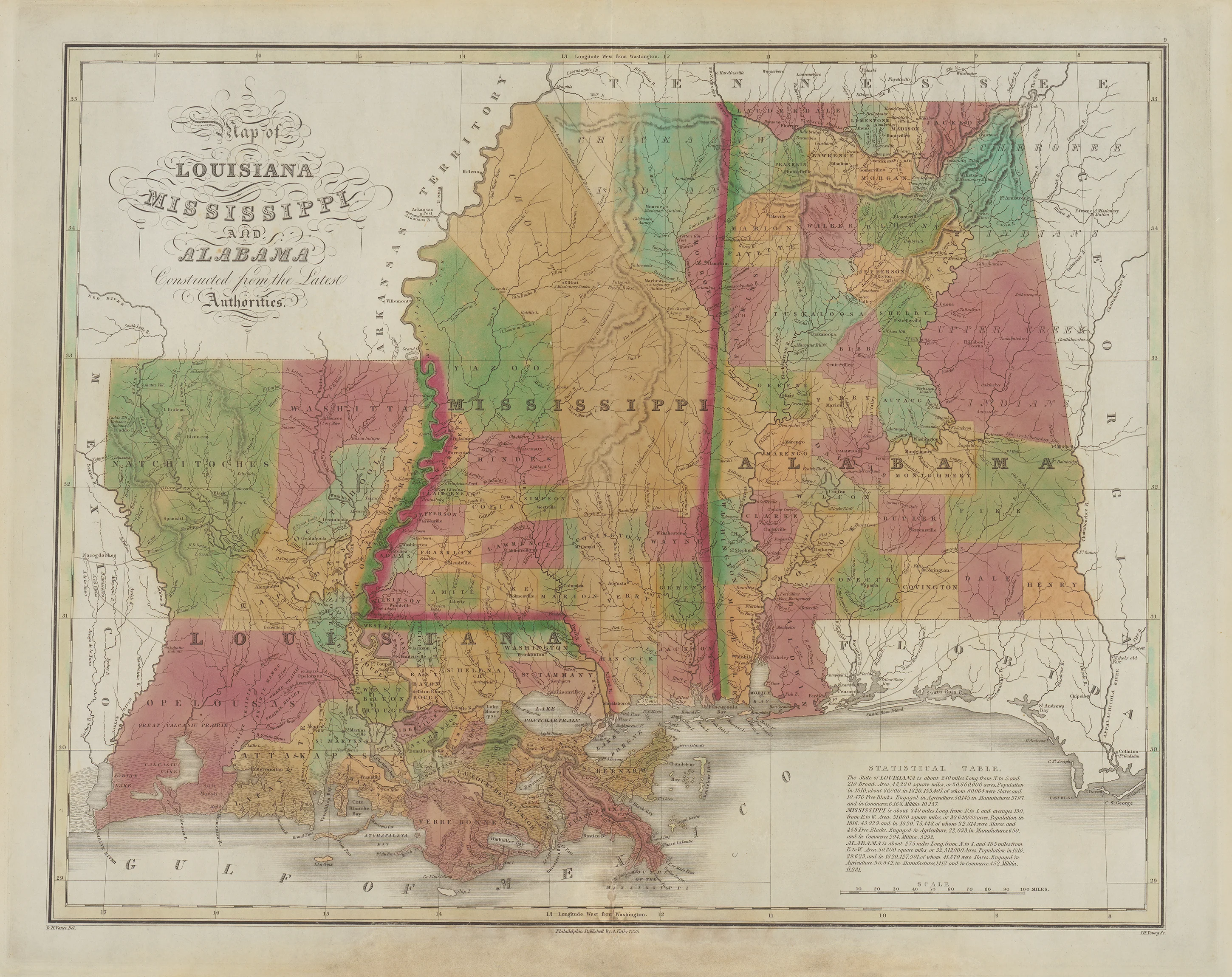
Map of Kentucky and Tennessee, Complied From The Latest Authorities: Finley, 1826
- Title: Map of Kentucky and Tennessee, Complied From The Latest Authorities
- Author: Anthony Finley
- Date: 1826
- Condition: Mild age toning, visual paper restoration along the center margin. Faint offsetting throughout. All else fine.
- Inches: 21 3/4 x 17 1/8 [Image]
- Centimeters: 53.34 x 43.49 [Image]
- Product ID: 308399
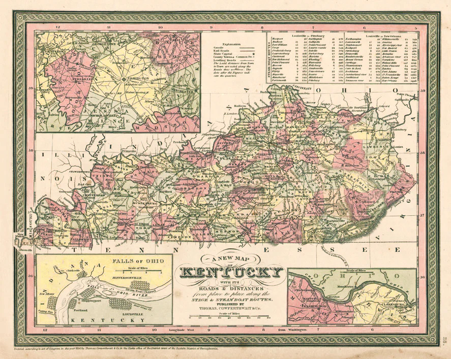
This highly detailed map of Kentucky and Tennessee from Finley's New American Atlas lists major cities, towns, rivers, and transportation routes are labeled throughout both states. A statistical table on the left side provides additional information about the two states. The map’s borders are finely engraved, and the overall presentation is both decorative and informative, reflecting the cartographic style of the period.
Background on Creator
Anthony Finley (August 25, 1784 – June 9, 1836) was a prominent American book and map publisher based in Philadelphia, Pennsylvania. He began his publishing career around 1809, opening a bookshop and publishing house at Fourth and Chestnut Street in Philadelphia. His earliest known catalog, featuring scientific works, appeared in 1811, and that same year he produced his first maps for Daniel Edward Clarke’s Travels in Various Countries of Europe, Asia, and Africa.
Finley published his first atlas, the Atlas Classica, in 1818, followed by the influential “A New General Atlas” and “A New American Atlas”, both of which saw multiple editions between 1824 and 1834. His atlases were highly regarded for their clarity and quality, and he was among the first American publishers to produce high-quality maps domestically rather than relying on imported works. While much of his cartographic material drew from European sources, Finley’s publications were admired and widely used.
- Title: Map of Kentucky and Tennessee, Complied From The Latest Authorities
- Author: Anthony Finley
- Date: 1826
- Condition: Mild age toning, visual paper restoration along the center margin. Faint offsetting throughout. All else fine.
- Inches: 21 3/4 x 17 1/8 [Image]
- Centimeters: 53.34 x 43.49 [Image]
- Product ID: 308399
This highly detailed map of Kentucky and Tennessee from Finley's New American Atlas lists major cities, towns, rivers, and transportation routes are labeled throughout both states. A statistical table on the left side provides additional information about the two states. The map’s borders are finely engraved, and the overall presentation is both decorative and informative, reflecting the cartographic style of the period.
Background on Creator
Anthony Finley (August 25, 1784 – June 9, 1836) was a prominent American book and map publisher based in Philadelphia, Pennsylvania. He began his publishing career around 1809, opening a bookshop and publishing house at Fourth and Chestnut Street in Philadelphia. His earliest known catalog, featuring scientific works, appeared in 1811, and that same year he produced his first maps for Daniel Edward Clarke’s Travels in Various Countries of Europe, Asia, and Africa.
Finley published his first atlas, the Atlas Classica, in 1818, followed by the influential “A New General Atlas” and “A New American Atlas”, both of which saw multiple editions between 1824 and 1834. His atlases were highly regarded for their clarity and quality, and he was among the first American publishers to produce high-quality maps domestically rather than relying on imported works. While much of his cartographic material drew from European sources, Finley’s publications were admired and widely used.
Original: $695.00
-65%$695.00
$243.25Description
- Title: Map of Kentucky and Tennessee, Complied From The Latest Authorities
- Author: Anthony Finley
- Date: 1826
- Condition: Mild age toning, visual paper restoration along the center margin. Faint offsetting throughout. All else fine.
- Inches: 21 3/4 x 17 1/8 [Image]
- Centimeters: 53.34 x 43.49 [Image]
- Product ID: 308399
This highly detailed map of Kentucky and Tennessee from Finley's New American Atlas lists major cities, towns, rivers, and transportation routes are labeled throughout both states. A statistical table on the left side provides additional information about the two states. The map’s borders are finely engraved, and the overall presentation is both decorative and informative, reflecting the cartographic style of the period.
Background on Creator
Anthony Finley (August 25, 1784 – June 9, 1836) was a prominent American book and map publisher based in Philadelphia, Pennsylvania. He began his publishing career around 1809, opening a bookshop and publishing house at Fourth and Chestnut Street in Philadelphia. His earliest known catalog, featuring scientific works, appeared in 1811, and that same year he produced his first maps for Daniel Edward Clarke’s Travels in Various Countries of Europe, Asia, and Africa.
Finley published his first atlas, the Atlas Classica, in 1818, followed by the influential “A New General Atlas” and “A New American Atlas”, both of which saw multiple editions between 1824 and 1834. His atlases were highly regarded for their clarity and quality, and he was among the first American publishers to produce high-quality maps domestically rather than relying on imported works. While much of his cartographic material drew from European sources, Finley’s publications were admired and widely used.