Geological Map of Grant Parish Louisiana: Fisk 1938
- Title: Geological Map of Grant Parish Louisiana
- Author: H. N. Fisk
- Date: 1938
- Medium: Chromolithograph
- Condition: Very Good - folded
- Inches: 46 x 30 1/4 [Paper]
- Centimeters: 116.84 x 76.84 [Paper]
- Product ID: 319047
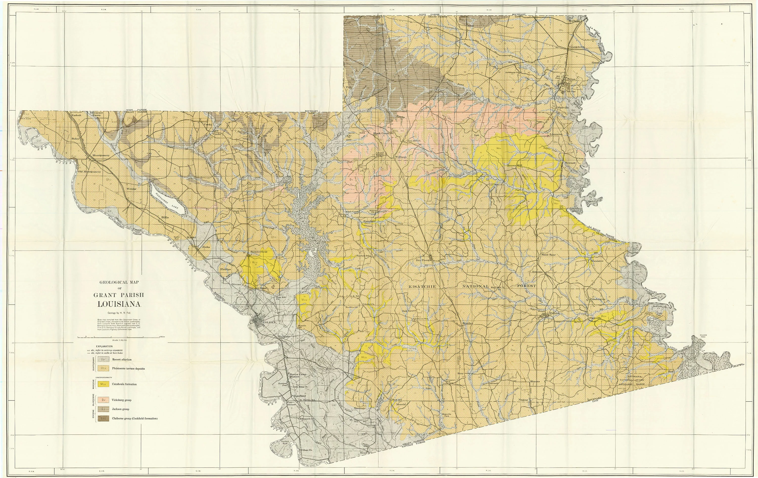
Geological map of Grant Parish in central Louisiana. Shows formations from the Quaternary, Miocene, Oligocene, and Eocene Periods, differentiated by color. Also depicts the city of Colfax, the Kisatchie National Forest, Nantaches Lake, and the Red River.
This map and report are foundational references for understanding the geology and geomorphology of central Louisiana, especially the Red River valley. The mapping of Quaternary alluvium, Pleistocene terraces, and underlying Tertiary deposits has informed subsequent research on the region’s landscape evolution, sedimentation, and hydrocarbon potential.
- Title: Geological Map of Grant Parish Louisiana
- Author: H. N. Fisk
- Date: 1938
- Medium: Chromolithograph
- Condition: Very Good - folded
- Inches: 46 x 30 1/4 [Paper]
- Centimeters: 116.84 x 76.84 [Paper]
- Product ID: 319047
Geological map of Grant Parish in central Louisiana. Shows formations from the Quaternary, Miocene, Oligocene, and Eocene Periods, differentiated by color. Also depicts the city of Colfax, the Kisatchie National Forest, Nantaches Lake, and the Red River.
This map and report are foundational references for understanding the geology and geomorphology of central Louisiana, especially the Red River valley. The mapping of Quaternary alluvium, Pleistocene terraces, and underlying Tertiary deposits has informed subsequent research on the region’s landscape evolution, sedimentation, and hydrocarbon potential.
Original: $375.00
-65%$375.00
$131.25Description
- Title: Geological Map of Grant Parish Louisiana
- Author: H. N. Fisk
- Date: 1938
- Medium: Chromolithograph
- Condition: Very Good - folded
- Inches: 46 x 30 1/4 [Paper]
- Centimeters: 116.84 x 76.84 [Paper]
- Product ID: 319047
Geological map of Grant Parish in central Louisiana. Shows formations from the Quaternary, Miocene, Oligocene, and Eocene Periods, differentiated by color. Also depicts the city of Colfax, the Kisatchie National Forest, Nantaches Lake, and the Red River.
This map and report are foundational references for understanding the geology and geomorphology of central Louisiana, especially the Red River valley. The mapping of Quaternary alluvium, Pleistocene terraces, and underlying Tertiary deposits has informed subsequent research on the region’s landscape evolution, sedimentation, and hydrocarbon potential.