A New Map of Ireland: Moll, c.1725
- Title: A New Map of Ireland
- Author: Herman Moll
- Date: c.1725
- Condition: Very good - discoloration at folds, refreshed color
- Inches: 24 1/8 x 40 1/8 [Image]
- Centimeters: 61.27 x 101.91 [Image]
- Product ID: 308290
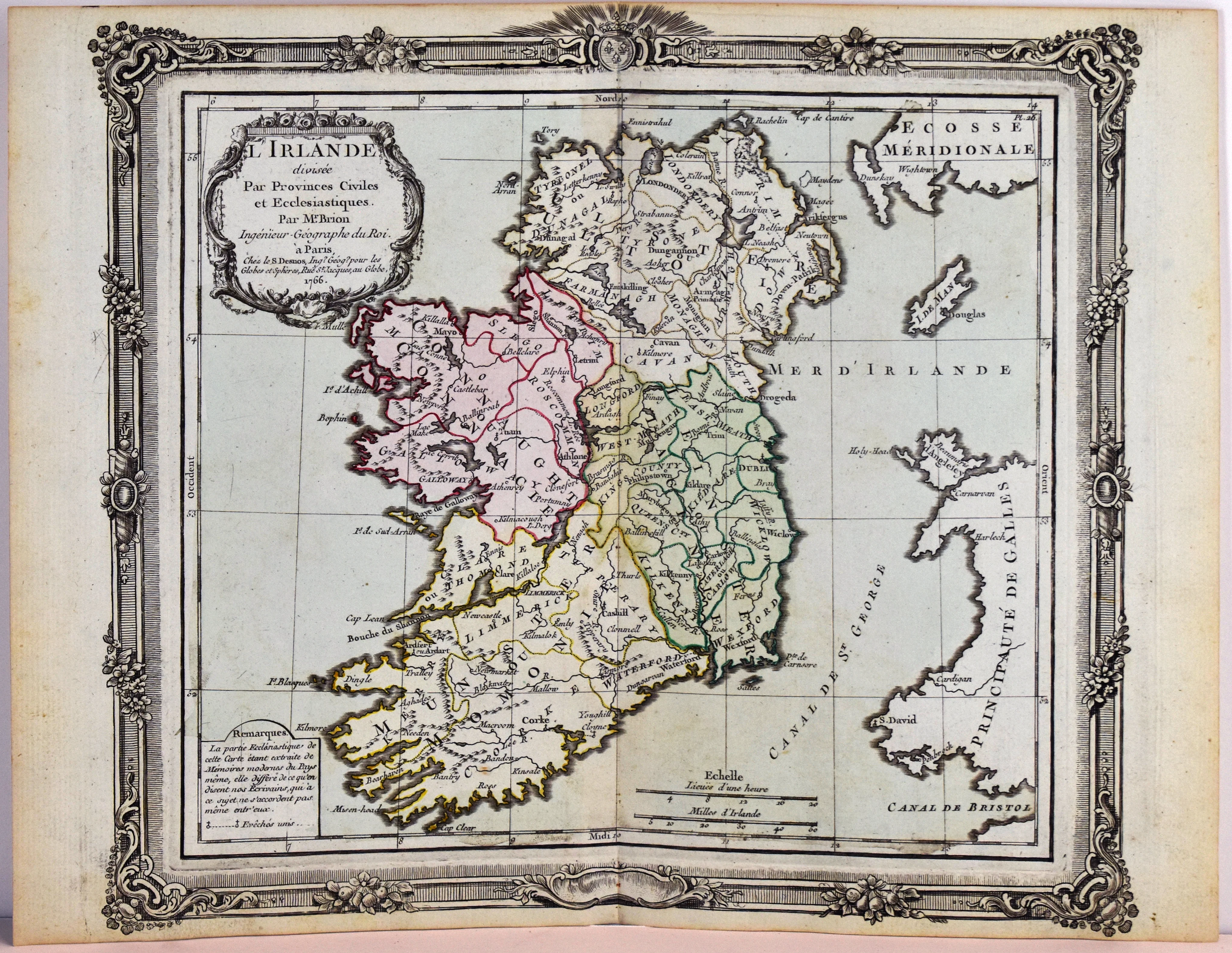
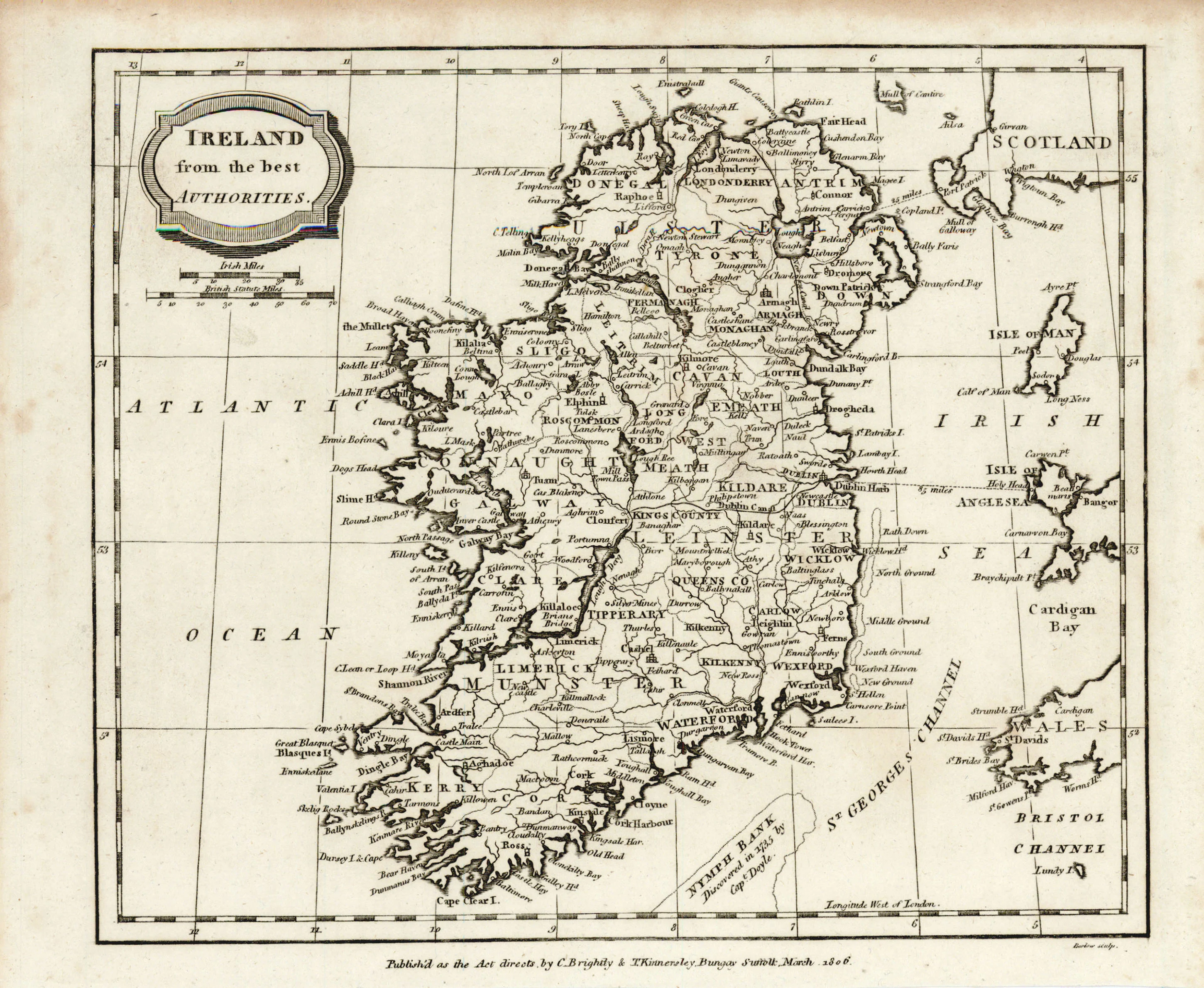
A New Map of Ireland divided into its Provinces, Counties and Baronies, wherein are distinguished the Bishoprics, Borroughs, Barracks, Bogs, Passes, Bridges, & c. with the Principal Roads, and the common reputed miles.
Moll's map of Ireland reflects the complex political and military landscape of the time. Created in the aftermath of the Treaty of Limerick and during the implementation of the Penal Laws, the map provides detailed information on barracks and troop placements, illustrating how military considerations shaped the portrayal of Ireland's geography.
Beyond the main map, Moll included inset plans of key cities such as Galloway, Waterford, Limerick, Dublin, and Cork.
The map exemplifies Moll's cartographic skill, blending geographical accuracy with rich contextual details. The map not only serves as a geographical reference but also as a historical document, capturing the socio-political realities of early 18th century Ireland.
Herman Moll (c. 1654-1732) made his career in London as a cartographer, publisher, and eventually a producer of pocket globes. However, his birthplace and exact nationality remain unknown. Many assume he could be Dutch due to his involvement in Dutch cartography, the prevalence of the surname ‘Moll’ in the Low Countries at the time, and a trip he took later in life to the region. However, ‘Moll’ was also a German name, casting this hypothesis into doubt. Moll enjoyed a long and successful career, collaborating frequently with other London publishers and engravers and earning an esteemed reputation among his intellectual contemporaries. In fact, he is mentioned by name in Jonathan Swift’s famous novel Gulliver’s Travels (1726). His maps, noted for their ornament and beauty, retained their influence long after his death, and today remain highly collectible.
- Title: A New Map of Ireland
- Author: Herman Moll
- Date: c.1725
- Condition: Very good - discoloration at folds, refreshed color
- Inches: 24 1/8 x 40 1/8 [Image]
- Centimeters: 61.27 x 101.91 [Image]
- Product ID: 308290
A New Map of Ireland divided into its Provinces, Counties and Baronies, wherein are distinguished the Bishoprics, Borroughs, Barracks, Bogs, Passes, Bridges, & c. with the Principal Roads, and the common reputed miles.
Moll's map of Ireland reflects the complex political and military landscape of the time. Created in the aftermath of the Treaty of Limerick and during the implementation of the Penal Laws, the map provides detailed information on barracks and troop placements, illustrating how military considerations shaped the portrayal of Ireland's geography.
Beyond the main map, Moll included inset plans of key cities such as Galloway, Waterford, Limerick, Dublin, and Cork.
The map exemplifies Moll's cartographic skill, blending geographical accuracy with rich contextual details. The map not only serves as a geographical reference but also as a historical document, capturing the socio-political realities of early 18th century Ireland.
Herman Moll (c. 1654-1732) made his career in London as a cartographer, publisher, and eventually a producer of pocket globes. However, his birthplace and exact nationality remain unknown. Many assume he could be Dutch due to his involvement in Dutch cartography, the prevalence of the surname ‘Moll’ in the Low Countries at the time, and a trip he took later in life to the region. However, ‘Moll’ was also a German name, casting this hypothesis into doubt. Moll enjoyed a long and successful career, collaborating frequently with other London publishers and engravers and earning an esteemed reputation among his intellectual contemporaries. In fact, he is mentioned by name in Jonathan Swift’s famous novel Gulliver’s Travels (1726). His maps, noted for their ornament and beauty, retained their influence long after his death, and today remain highly collectible.
Original: $1,895.00
-65%$1,895.00
$663.25Description
- Title: A New Map of Ireland
- Author: Herman Moll
- Date: c.1725
- Condition: Very good - discoloration at folds, refreshed color
- Inches: 24 1/8 x 40 1/8 [Image]
- Centimeters: 61.27 x 101.91 [Image]
- Product ID: 308290
A New Map of Ireland divided into its Provinces, Counties and Baronies, wherein are distinguished the Bishoprics, Borroughs, Barracks, Bogs, Passes, Bridges, & c. with the Principal Roads, and the common reputed miles.
Moll's map of Ireland reflects the complex political and military landscape of the time. Created in the aftermath of the Treaty of Limerick and during the implementation of the Penal Laws, the map provides detailed information on barracks and troop placements, illustrating how military considerations shaped the portrayal of Ireland's geography.
Beyond the main map, Moll included inset plans of key cities such as Galloway, Waterford, Limerick, Dublin, and Cork.
The map exemplifies Moll's cartographic skill, blending geographical accuracy with rich contextual details. The map not only serves as a geographical reference but also as a historical document, capturing the socio-political realities of early 18th century Ireland.
Herman Moll (c. 1654-1732) made his career in London as a cartographer, publisher, and eventually a producer of pocket globes. However, his birthplace and exact nationality remain unknown. Many assume he could be Dutch due to his involvement in Dutch cartography, the prevalence of the surname ‘Moll’ in the Low Countries at the time, and a trip he took later in life to the region. However, ‘Moll’ was also a German name, casting this hypothesis into doubt. Moll enjoyed a long and successful career, collaborating frequently with other London publishers and engravers and earning an esteemed reputation among his intellectual contemporaries. In fact, he is mentioned by name in Jonathan Swift’s famous novel Gulliver’s Travels (1726). His maps, noted for their ornament and beauty, retained their influence long after his death, and today remain highly collectible.